


| DESIGNATED AREAS | |
As of 1948, when the First National Park “Pelister” was designated in the Republic of Macedonia, the number and the total surface area of different categories of protected areas have noted permanent growth on national level.
At this moment, due to the new categorization of designated areas established under the new Law on Nature Protection, in accordance with the IUCN categorization, the designated area system is in transition and includes designated areas under the old and under the new categorization. The analysis (in relation to the number and the area) includes all designated areas in the Republic of Macedonia designated under the old and also under the new categorization. In doing so, the areas designated in accordance with the old categorization have been processed according to the appropriate/corresponding IUCN category. The analysis of the area of the designated areas has been made by rendering the borders of the areas in GIS.
Presently, the network of protected areas includes 86 areas in total and these occupy area of 229.900 haor 8.94% of the territory of the Republic of Macedonia. The largest portion is occupied by national parks and nature monuments.
Total of 35 sites have been identified in the National Emerald network of areas of special conservation interest. They occupy an area of 752.223 ha or 29% of its territory.
Figure 1. Total area of designated areas
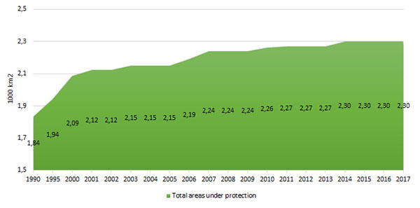
Figure 2. Area of designated areas by category of conservation
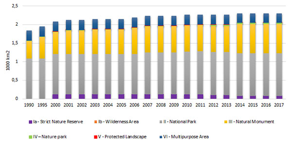
Figure 3. Share of individual national categories of designated areas in the overall territory of the Republic of Macedonia
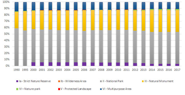
Figure 4.Total number of designated areas

Figure 5. Area of identified Emerald areas
Data coverage: excel
Source: MoEPP -CDDA, Emerald database (https://arhiva.moepp.gov.mk/?lang=en)
1. Designated areas at national level
Under the 2004 Law on Nature Protection, new categorization of designated area is introduced, aligned with the International Union for Conservation of Nature (IUCN), enabling inclusion of the national designated areas in the world network of designated areas. The Law stipulates a responsibility that, within 6 years, all designated areas (nominated before 2004) to be re-evaluated and designated accordance with the new categorization. Because of the current transitional period, the network of designated areas (areas designated according to the new categorization redesignated areas) the analysis (regarding the number and area they occupy) includes all designated areas in the Republic of Macedonia, designated under the old and also the new categorization. In doing so, the areas designated in accordance with the old categorization have been processed according to the appropriate/corresponding IUCN category. The analysis of the area of the designated areas has been made by rendering the borders of the areas in GIS (according to the data from the acts of designation or redesignation of areas, the Spatial Plan of the Republic of Macedonia, and where precise data in the Spatial Plan were missing, the area of the designated areas was rendered in accordance with the experts opinion).[1]
In the analyzed period, the area of designated areas has grown, i.e. the share of designated areas in the overall area of Macedonia in 1990 was 7.14% and in 2017 it grew to 8.94%. Also, the number of designated areas recorded increase from 67 in 1990 to 86 areas in 2017, most of which – 67 areas – belong to natural monuments, followed by nature park with 12 areas.
Thus, currently the designated area network comprises 86 areas, with total area of 229.900 haor 8.94% of the territory of Macedonia.
Most of it falls into the category national parks with around 4.47%, then natural monuments with 3.07% and the multipurpose area Jasen with 0,97% of the national territory.
[1]The analysis of the number and area of designated areas, i.e. the rendering of the borders in GIS has been done during 2010-2011, within the UNDP and GEF project „Strenghtening the environmental, institutional and financial sustainability of the system of designated areas in the Republic of Macedonia“.
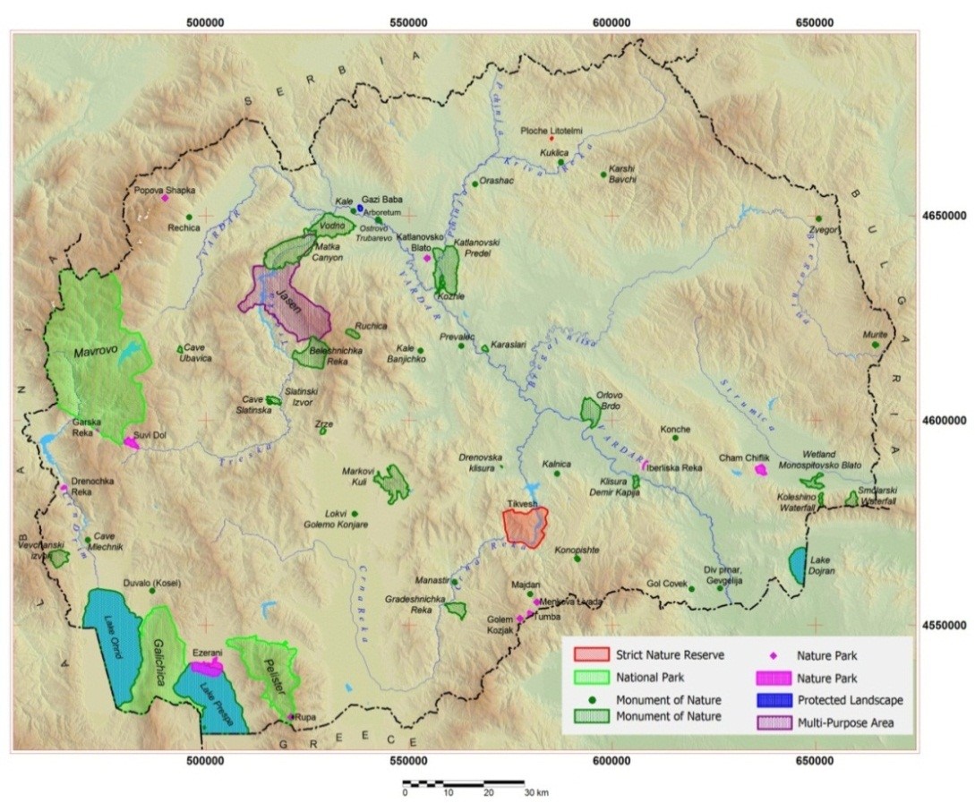
Map 1. National designated areas
2. Designated areas with internationally recognized status
- Monument of Nature “Ohrid Lake” – World Natural Heritage (UNESCO);
- Monument of Nature “Prespa Lake” – Ramsar Site (1995);
- Monument of Nature “Dojran Lake” – Ramsar Site (2008);
- Monument of Nature “Markovi Kuli” (King Marko’s Towers) – World Natural Heritage (UNESCO’s Tentative List); and
- Monument of Nature “Slatinski izvor” (The Springs of Slatino) – World Natural Heritage (UNESCO’s Tentative List).
- Biosphere Ohrid-Prespa Reserve – World Natural Heritage (UNESCO) (2014).
3. Emerald network
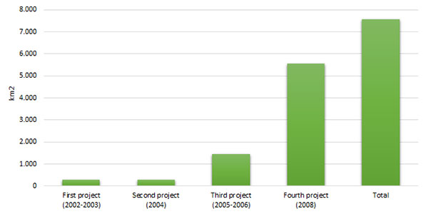
4 phase process was implemented in the Republic of Macedonia from 2002 to 2008 to identify the areas of special conservation interest (ASCI) and establish the Emerald Network. This network is established on the territory of the countries Parties to the Bern Convention and important part in the preparation of candidate countries for EU membership for the implementation of the EU Birds and/or Habitats Directives, or an additional tool in the process of establishing the coherent European Environmental Network Natura 2000.
35 locations have been identified in the National Emerald network. Under the first project, implemented in 2002-2003, 3 areas have been identified: SNR Ezerani, NP Galicica and SR Dojran Lake, with a total area of 27.660 ha (3,6%). In 2004 a second project was implemented, identifying another 3 areas: SNR Tikves, NP Pelister, SR Demir Kapija, with a total area of 28.000 ha (3,8%). Under the third project implemented in 2005-2006, ten areas with a total area of 144.783 ha (19,1%) were identified, while with the fourth project (implemented in 2008), another 19 areas were identified with a total area of 556.447 ha (73,5%). The National Emerald Network of the Republic of Macedonia identifies 35 areas covering and area of 752.223 ha or around 29% of its territory.
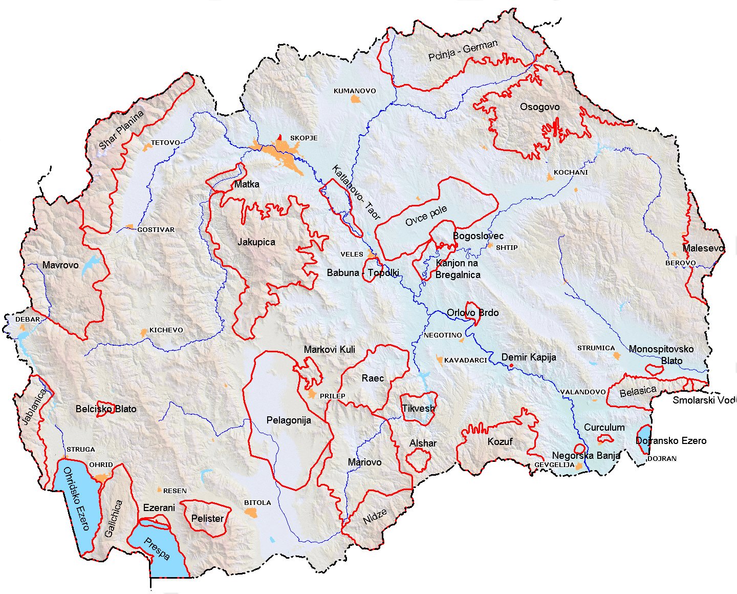
Map 2. National Emerald network of the Republic of Macedonia
4. Natura 2000 ecological network
The Natura 2000 ecological network has been established in the territories of EU member states with the aim to secure the biodiversity by means of conservation of the natural habitats and wild flora and fauna.
The obligation to establish Natura 2000 comes from the Article 3 of the Directive of the conservation of natural habitats and wild flora and fauna (92/43/EEC). Measures taken under this Directive are intended to maintain/or restore to a favourable conservation status of natural habitats and wild plant and animal species which are of EU interest.
The Natura 2000 environmental network includes “Specially Protected Areas” (SPA’s) – defined in accordance with the Wild Bird Conservation Directive and Directive on the Conservation of Natural Habitats and Wild Fauna and Flora (Habitat Directive).
Article 52 of the Law on Nature Protection, provides a legal basis for the establishment of the Natura 2000 ecological network.
The MoEPP is currently implementing activities for further harmonization of the national legislation on nature protection with the EU legislation, as well as the Directives on habitats and birds. In this direction, identification of habitats and species of European importance on the national level, has been carried out and nine (9) areas have been identified as potential areas for Natura 2000 and two (2) areas with high natural potential. Three (3) of them are proposed as potential Special Protection Areas (SPA) under the Birds Directive, and six (6) areas as Site of Community Importance (SCI) in accordance with the Habitats Directive:
- Dojran Lake (SPA)
- Ohrid Lake (SPA)
- Prespa Lake (SPA)
- Mavrovo (SCI)
- Shar Planina area with high natural potential
- Jakupica (SCI)
- Ovche Pole (SCI)
- Cave Ubavica (SCI)
- Galicica (SCI)
- Pelister (SCI)
- Mariovo and Kozuf areas with high natural potential
5. Natural rarities
The Law on Nature Protection under Article 90-a, provides a legal basis for the protection of certain parts of nature, like natural rarities. Certain rare, endangered and endemic, plants and animal species, their parts and communities, landscape forms, geological profiles, paleontological and speleological objects, can be declared as natural rarity, if their area is less than 100 hectares.
Pursuant to the Law on Nature Protection, the Dona Duka Cave (Official Gazette of the Republic of Macedonia No. 182/2011) and the Platanus orientalis in Morodvis (Official Gazette of the Republic of Macedonia No. 65/2016) were declared as natural rarities.
There are ongoing activities for the valorization and proclamation of ten localities/individual stems as natural rarities in the East Planning Region and the Ohrid region.